What if the ease of your daily commute was decided over 300 years ago?
Many major American cities have roots in old plans. William Penn founded Philadelphia in 1682. He used a rectilinear grid layout for the streets. This design still shapes movement today.
The dense urban core, known as Center City, benefits from this grid. It allows for efficient movement. A complex network of roads and rails connects diverse neighborhoods.
Modern arteries like the Delaware Expressway (I-95) and the Schuylkill Expressway (I-76) are critical. They handle intercity traffic flow. Understanding this mix of history and concrete is key to getting around.
Mastering transit in the U.S. often starts with recognizing how past planning influences present-day accessibility. The systems are built on this foundation.
Key Takeaways
- Historical urban planning, like Philadelphia’s 1682 grid, directly impacts modern transit efficiency.
- Major metropolitan areas rely on integrated networks of roads, rails, and buses.
- Key highways such as I-95 and I-76 are vital arteries for regional traffic flow.
- Understanding the layout of a city’s core, like Center City, is crucial for navigation.
- Effective use of transit systems requires familiarity with both historical design and current infrastructure.
- The connection between neighborhoods and central business districts is a priority for transportation networks.
Introduction to Public Transportation in the US
Efficient travel in metropolitan areas hinges on integrated transit systems. These networks provide vital links for daily life.
Overview of Transportation Options
American mobility systems include rapid subways, buses, and commuter rails. This variety serves entire urban regions effectively.
From local trolleys to extensive regional lines, choices abound. Each mode connects people to jobs, schools, and services.
Significance for Urban and Suburban Travelers
Reliable transit is essential for daily commutes. Philadelphia ranked as the second most traffic-congested U.S. city in 2019.
Its system connects the city to towns across the Northeast megalopolis. This reduces reliance on personal vehicles.
Commuters heading into Center City benefit from diverse options. These choices ease challenges like heavy traffic and scarce parking.
Essential Guide to Planning Your Route
The key to efficient urban travel lies in identifying the major hubs that connect all routes. With the right approach, navigating even complex networks becomes straightforward.
Mapping Key Transit Hubs and Stations
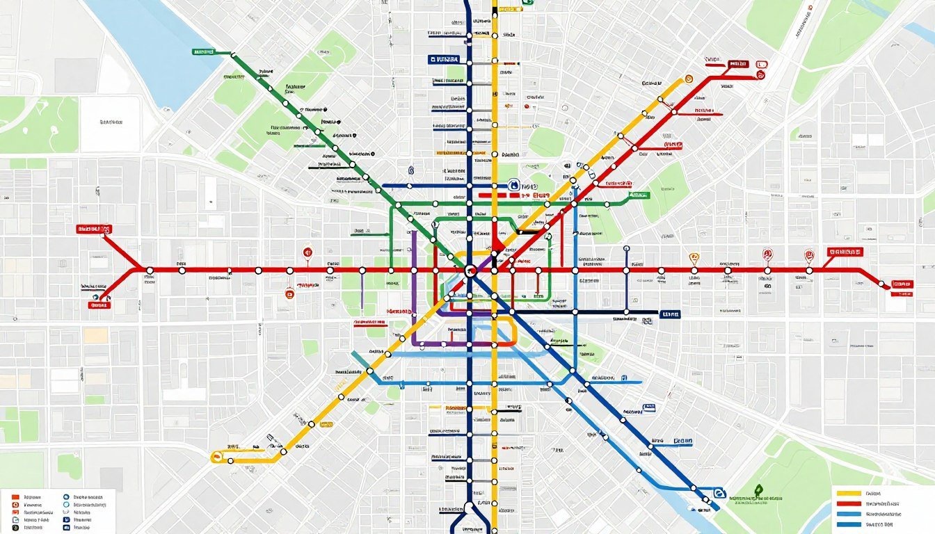
Planning often begins at 30th Street Station. This major hub serves 13 SEPTA Regional Rail routes and 11 Amtrak lines.
It provides seamless connectivity between different travel modes. The underground concourse in Center City spans 3.5 miles.
This network lets pedestrians move efficiently between points like 8th Street and 18th Street.
Utilizing Online Tools and Apps
Digital resources offer vital schedule and fare information. Official websites and mobile apps help map your entire journey.
These tools ensure every station stop is accounted for. They transform complex travel into simple, step-by-step directions.
Understanding Public Transportation
From bustling subways to neighborhood trolleys, each transit mode serves a distinct purpose. The Southeastern Pennsylvania Transportation Authority (SEPTA) operates this vast network.
Modes of Transit: Bus, Train, Trolley
The system relies on a diverse fleet. Buses form the largest part, with 117 routes crisscrossing the region.
They provide essential links between residential areas and commercial hubs like Center City.
For faster travel, the Market-Frankford Line and Broad Street Line are vital. Together, they serve over 316,000 riders every day.

Intercity vs. Local Transit Services
It’s important to distinguish between local and longer-distance options. Local services focus on movement within the city.
They include buses, subways, and trolleys that stop frequently. Intercity lines connect Philadelphia to suburbs and other regions.
SEPTA manages both types, ensuring comprehensive coverage. Knowing which service to use saves time and confusion.
Exploring the SEPTA Transit System
The Southeastern Pennsylvania Transportation Authority (SEPTA) forms the backbone of regional mobility. This integrated network seamlessly connects the city to its surrounding suburbs.
Overview of SEPTA’s Rail, Bus and Trolley Lines
SEPTA operates a comprehensive mix of rail, bus, and trolley lines. The City Transit Division alone runs 76 bus routes for extensive coverage.
It also manages unique trackless trolleys on Routes 59, 66, and 75. These electric vehicles offer quiet, reliable service along key corridors.
Tips for First-Time SEPTA Riders
New riders should get a SEPTA Key card immediately. This contactless card simplifies payment across all modes.
Familiarize yourself with the bus and trolley routes serving your area. Consistent service connects neighborhoods to the busy Center City hub.
This knowledge helps you traverse the city efficiently and avoid common navigation pitfalls.
Deep Dive into Philadelphia’s Rail and Subway Networks
Philadelphia’s underground arteries pulse with a rhythm all their own, moving thousands daily beneath the city streets. This network forms the core of rapid transit for the entire region.
Market-Frankford and Broad Street Lines
The Market-Frankford Line and Broad Street Line are the backbone. Together, they cover 25 miles and serve 50 stations.
These primary subway lines connect distant neighborhoods to the bustling heart of downtown. The Broad Street Line itself offers both express and local service.
Subway-Surface Trolleys and Regional Rail Connections
Another key layer is the Subway-Surface trolley lines. They run in a dedicated tunnel from university campuses to City Hall.
This provides a direct link into Center City for these trolleys. The network is designed for easy transfers.
Regional Rail connections are fully integrated. This allows seamless movement between the Broad Street Line and other major lines.
These rail and subways are essential. They maintain vital mobility across the urban landscape.
Detailed Guide to SEPTA Bus and Trolley Services
Beyond the subways, a vast fleet of buses and trolleys provides the essential connective tissue for city neighborhoods. These surface routes deliver direct access to destinations that rail lines cannot reach.
Operating Hours and Frequency of Routes
SEPTA bus and trolley services run on varied schedules. Many routes offer frequent service throughout the day.
For late-night travel, specific “Night Owl” bus lines operate. They replace subway service during overnight closures. This ensures transit availability around the clock.
Trackless Trolleys and Special Bus Services
The system includes unique trackless trolley lines. These electric vehicles run on Routes 59, 66, and 75.
Route 66 connects directly to the Market-Frankford Line. This link is at the Frankford Transportation Center. It allows for easy transfers between modes.
Riders can rely on these diverse options. They maintain critical links between residential areas and bustling Center City. Detailed schedule information is always available to help plan any trip.
Getting Around Center City and Key Attractions
Center City’s compact layout invites visitors to discover its treasures on foot or by bike. This area is highly walkable, with many key sites within easy distance.
Walking, Biking, and the Philly PHLASH
Exploring Center City by bike is efficient and fun. The Indego bike share program offers 2,000 bicycles across 250 stations.
To visit popular attractions, use the Philly PHLASH Downtown Loop. This seasonal bus service is managed by the Independence Visitor Center Corporation.
Parking and Ride Sharing Alternatives
If walking isn’t ideal, numerous ride-sharing alternatives are available. Parking options also exist near every major station and tourist location.
These diverse transit choices enhance mobility throughout city streets. They provide easy access to cultural and historical spots. City buses and other options connect all major attractions.
Traveling Beyond Philadelphia: Regional Rail and NJ Transit
For journeys extending beyond the city limits, robust rail services provide seamless access to neighboring states and airports. The regional network is centered on major hubs like 30th Street Station.
Connecting to New Jersey and the Northeast Corridor
30th Street Station is your gateway to the wider region. It offers direct links to the Northeast Corridor for Amtrak trains and NJ Transit services into New Jersey.
Travelers can also use the PATCO Speedline. This line crosses the Benjamin Franklin Bridge to reach Camden and other cities. These services run frequently throughout the day.
Accessing Airports and Amtrak Links
Reaching the Philadelphia International Airport is straightforward. Take the SEPTA Regional Rail Airport Line from key stops like Suburban Station or Jefferson Station.
This train provides reliable access to the airport terminals. From there, connections to New York and other destinations are easy. The entire regional rail network ensures you stay well-connected.
Tips for Safe and Accessible Transit Travel
The key to a stress-free trip involves using modern payment systems and staying informed. A little preparation ensures everyone can navigate the network with confidence and ease.

Focus on the tools designed for your convenience and simple strategies to avoid delays. This approach makes exploring the entire region smoother.
Accessibility Features and SEPTA Key Card Benefits
Start with the SEPTA Key card. This reloadable, contactless chip is your all-access pass. It works seamlessly on every bus, train, and subway.
For riders needing step-free access, the system is accommodating. All stations on the SEPTA Regional Rail Airport Line are wheelchair accessible. This provides reliable access to a major travel hub.
Strategies to Avoid Common Pitfalls
Always check service hours and schedules before you go. This is especially important for late-night travel or on specific lines like the Broad Street Line.
Confirm your station location and the correct platform for your train or bus. Having the right information prevents wrong turns.
Use real-time updates to safely visit attractions and neighborhoods throughout city areas. Knowing the plan helps all riders enjoy a smooth journey from start to finish.
Conclusion
Navigating a vibrant cityscape is less about maps and more about knowing the flow of its daily transit life. Philadelphia’s network offers a reliable way to explore rich history and culture.
By using the diverse range of buses, trains, and trolleys, you connect neighborhoods to the bustling metropolitan heart. This access turns commutes and sightseeing into efficient journeys.
Staying informed with schedules and tools like the SEPTA Key card ensures a seamless experience for every passenger. This modern approach simplifies travel.
The city’s transit infrastructure remains a vital part of daily life. We hope this guide helps you travel with confidence and ease throughout your journey.
FAQ
What is the best way to plan my route on Philadelphia’s transit system?
Use the official SEPTA website or mobile app. These tools provide real-time schedules, trip planning, and service alerts. For navigating Center City, maps of the Broad Street Line and Market-Frankford Line are especially helpful.
How do I get from 30th Street Station to the Philadelphia International Airport?
Take the SEPTA Regional Rail Airport Line. It runs directly from 30th Street Station to all airport terminals. This is the fastest and most convenient service, with trains departing every 30 minutes.
What is the difference between a trolley and a bus in Philadelphia?
Trolleys (or streetcars) often run on fixed rails, like the Subway-Surface trolley lines. Buses are more flexible and cover wider areas. Some trolley lines operate underground in Center City before surfacing in neighborhoods.
Can I use one fare card for all SEPTA buses, trains, and trolleys?
Yes. The SEPTA Key card is accepted on all trains, buses, and trolleys. It simplifies travel across different modes of transit, including Regional Rail, subway lines, and bus routes.
How do I travel from Philadelphia to New Jersey using public transit?
Use the PATCO Speedline from Center City to several New Jersey towns. You can also connect via SEPTA’s Regional Rail to Trenton, then transfer to NJ Transit trains heading to New York City and other destinations.
Are there good transit options for visiting major attractions?
Absolutely. The Philly PHLASH Downtown Loop bus connects key attractions. Many sites are also near Jefferson Station or Suburban Station. The Broad Street Line serves stadiums and the Museum District.
What are the main subway lines in Philadelphia?
The two primary subway lines are the Market-Frankford Line (east-west) and the Broad Street Line (north-south). They intersect at 15th Street Station and 30th Street Station, providing extensive access to neighborhoods.
How accessible is the transit system for riders with disabilities?
SEPTA offers many accessibility features. Most stations, buses, and trolleys are equipped with ramps or lifts. The SEPTA Key card also helps manage fares easily. Always check for specific service alerts regarding elevator status.